|
|
Post by RKC on Jul 31, 2016 15:59:48 GMT 12
G'day,  Regards, Rob (RKC) |
|
|
|
Post by esintes on Jul 31, 2016 22:05:45 GMT 12
|
|
|
|
Post by RKC on Jul 31, 2016 22:36:49 GMT 12
G'day esintes, It was the Rocky river in Tasman. Regards, Rob (RKC) |
|
|
|
Post by esintes on Aug 1, 2016 13:34:10 GMT 12
Thanks Rob. Another pin in my map for if I'm ever over that way.
|
|
|
|
Post by RKC on Aug 1, 2016 16:53:30 GMT 12
G'day esintes, The Collingwood goldfield is well worth a visit for everyone with an interest in gold mining. You can't go too wrong with the weather if you go in January, February or March. It can rain a great deal in Spring and early Summer however. I was camped near the Aorere river once just before Christmas when there was a massive weather bomb ... the Aorere river is a big river at any time, but when this weather bomb went off the river spread out into the farmland flats and cows were seen floating down the river to sail past Collingwood and out to sea. On the radio news they even reported some cows were lifted out one farm to float downstream and then be deposited in another farmers paddock. When I used to knock around there it was before the national Park came into existence. Nowadays, before you go anywhere in there it would be wise to check a topo map for the boundaries of the National Park. Most of the old goldfields are now unfortunately in the park boundaries ... including most of the Slate river. There is a massive old hydraulic sluicing mine in the lower reaches of the Slate river that is a treat to visit. I think it might be just on the edge of the National Park and is a short walk in from the roads end. When I used to go in there I spent most of my time trying to find the start of the old tracks, and that used up a lot of my time. These days the aerial photos on Google Maps would make finding the best way into an area of interest much, much easier. I made a number of attempts to find the Quartz range goldfield but was unable to find the right track in. That goldfield has an interesting history and I regret not spending more time trying to find my way in. The Slate river is the most interesting goldfield in there. There is a good walking track from the tops down into Moonlight flat. But after Moonlight Flat, at least when I was last in there, the track disappears, and its then a matter of following the river upstream. I got up past the famous wire pool and it was well worth the trek. The old river bank workings on the Slate river were bonanza deposits for the miners of the 1800s with numerous nuggets of a significant size found. I made a number of attempts to get into the Rocky river but did not succeed. Although ... after a lot of research I found the most likely spot where the old miners track in there would have started from. 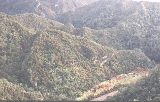 Looking down into Moonlight Flat. imagizer.imageshack.us/a/img922/7639/lDJ8Fp.jpgimagizer.imageshack.us/a/img923/2508/3Dgjqd.jpgRegards, Rob (RKC) |
|
|
|
Post by esintes on Aug 1, 2016 19:35:00 GMT 12
I'd love to explore up there properly. Always had the missus in tow when been up there before so a little tricky going too far off the beaten path. Will have to plan a proper adventure!
|
|
|
|
Post by eoinc on Dec 11, 2017 21:59:08 GMT 12
G'day esintes, ...I made a number of attempts to get into the Rocky river but did not succeed. Although ... after a lot of research I found the most likely spot where the old miners track in there would have started from. Looking down into Moonlight Flat... Regards, Rob (RKC) Hi, Rob. Is that Fletcher Creek coming in at the bottom left of that photo? Cheers, Eoin |
|
|
|
Post by RKC on Dec 12, 2017 8:39:35 GMT 12
G'day Eoin,
Yes, that is Fletcher creek running into the Slate at Moonlight Flat!
BTW: There seems to be some problems with photos appearing and then not appearing in threads. There is most likely some problem with my current photo hosting site. I'll sort it out when I can find time ... but, that might be months away yet.
Regards,
Rob (RKC)
|
|

